

GEORGE VANCOUVER 1757 -
(G2, G3a, G3b)
xxxxxThe English explorer George Vancouver sailed with Captain James Cook and served for nine years in the West Indies before leaving in 1791 to carry out a three-
Including:
Alexander Mackenzie and
The Constitutional Act (Canada)

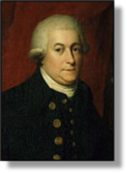 xxxxxThe English naval officer George Vancouver, born in King's Lynn, Norfolk, joined the navy at the age of 13 and served with the explorer Captain James Cook during his second and third voyages of discovery. Then in 1791, after serving nine years in the West Indies, he himself turned explorer and set out for the Pacific coast of North America, surveying parts of Australia, New Zealand, Tahiti, and Hawaii en route.
xxxxxHe spent the next three years carrying out a detailed survey of the intricate coastline from San Francisco Bay to British Columbia. He became the first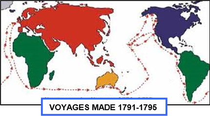 European to circumnavigate the island now named after him, and, having sailed as far north as Cook Inlet, off southern Alaska, became convinced that there was no Northwest Passage from the Pacific side. He returned to England in 1795, sailing via Cape Horn, and straight way began writing his A voyage of Discovery to the North Pacific Ocean and Round the World. This work, made up of three volumes and containing a large number of maps and plates, was published in 1798, the year of his death.
xxxxxIncidentally, the port of Granville was later renamed Vancouver in his honour, ...... Puget Sound was named after Peter Puget, one of his officers, ...... Bellingham and Bellingham Bay were named after Sir William Bellingham, who helped to finance his expedition, ...... and Mount Rainier, the highest peak of the Cascade Range, was named after a fellow navigator, Peter Rainier. ……
xxxxx…… Inx1789, two years before Vancouver began his survey of the northwest coast of America, the Spaniards seized four British merchant ships at Nootka Sound on the west coast of Vancouver Island. The Nootka Sound Controversy nearly caused a war between Britain and Spain, but by a convention of 1790 the Spanish relinquished their claim to the area -
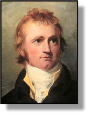 xxxxxWhile Vancouver was surveying the north-
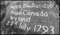 Mountains and reached the Pacific coast at Bellar Coola, at the mouth of Dean Channel. On his arrival, we are told, he selected a prominent piece of rock and recorded his achievement. Indeed, by these two journeys, he had became the first known explorer to cross Canada from east to west.
xxxxxIncidentally, Mackenzie's account of his exploration -
xxxxxOther explorers followed Mackenzie. As we shall see, the Englishman David Thompson, starting in 1798, spent over ten years studying the River Columbia from source to mouth, and in 1808 the Canadian Simon Fraser made a hazardous descent of the River "Fraser" to the site of present-
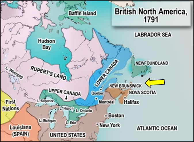
xxxxxBritish Columbia did not become part of Canada until 1871, but the year 1791 saw the passing of the Constitutional Act, another milestone in the history of that country. The influx of some 50,000 loyalists into Canada during and at the end of the American War of Independence threatened political and social rebellion. The British government, having already made concessions to the French via the Quebec Act of 1774 (G3a), took further measures to avoid conflict. The Constitutional Act divided the colony of Quebec into two provinces: Lower Canada (based on Quebec and mostly French speaking), and Upper Canada (based on Ontario and mostly English speaking), each with its own legislature. This provided a period of uneasy calm, but in 1837 troubles flared up again and led to the Union of Canada Act in 1841(Va), and, later, to the making of the Confederation of Canada by the British North America Act of 1867.
 xxxxxBritish Columbia -
xxxxxThis produced a solution of sorts by dividing the original colony of Quebec into two provinces along the line of the River Ottawa: Lower Canada (based on Quebec and mostly French speaking), and Upper Canada (based on Ontario and mostly English speaking), each with its own legislature. And by this time, due to loyalist pressure, New Brunswick had been formed out of Nova Scotia (arrowed on map). But, as we shall see, this Act, whilst staving off immediate rebellion, and providing an uneasy period of calm, eventually gave rise to a ruling elite in both Upper and Lower Canada. A serious armed revolt broke out in both provinces in 1837, ignited by a catalogue of political and social grievances, and this led to the Union of Canada Act in 1841(Va), and, later, to the Confederation of Canada, established by the British North America Act of 1867.
Acknowledgements
Vancouver: date and artist unknown – National Portrait Gallery, London. Map (The World): from captainvancouver.8m.com. Mackenzie: by the English portrait painter Thomas Lawrence (1769-
G3b-