

xxxxxThe first overland crossing of the United States was made by the Lewis and Clark expedition. It returned to St. Louis, Missouri, in 1806 after three years of exploration. Initiated by President Jefferson, it travelled to the Pacific Ocean and back - mostly by river - collecting information about the terrain, the native population, the soil conditions and the animal and plant life. Despite the hazards encountered, and the hardships suffered, it proved highly successful, and all members of the party were rewarded. The expedition was greatly assisted by the services of a French-Canadian interpreter named Toussaint Charbonneau, and his Indian wife Sacajawea.
THE LEWIS AND CLARK EXPEDITION
TO THE PACIFIC 1804 - 1806 (G3c)
Acknowledgements
Map (North America): licensed under Creative Commons – thorntonapush.wikispacescom. Clark: by the American painter Charles Willson Peale (1741-1827), c1807 – Lewis and Clark Trail Heritage Foundation, Great Falls, Montana, USA. Lewis: by the American painter Charles Willson Peale (1741-1827), c1807 – Lewis and Clark Trail Heritage Foundation, Great Falls, Montana, USA. River Travel: by the American painter Charles Marion Russell (1864-1926), 1905. Charbonneau: lithograph by the American illustrator Newell Convers Wyeth (1882-1945) – private collection. Map (Australia): licensed under Creative Commons. Author: Summerdrought –https://en.wikipedia.org. Scoresby: date and artist unknown – details Whitby Museum, North Yorkshire, England. Scoresby Jnr: c1810, artist unknown – details Whitby Museum, North Yorkshire, England. Map (Artic): licensed under Creative Commons – incredible-earth.wikispaces.com. Crow’s Nest: date and artist unknown.
xxxxxAt the beginning of the 19th century much of the interior of Africa and Australia still remained sketchy, if not totally unknown, the Arctic had only been skirted - mainly in an attempt to find a north-east or a north-west passage from Europe to the Far East - and Antarctica had not even been discovered. However, the major features of Europe were certainly well known; much of Asia had been mapped, and the Spanish and Portuguese had come to terms with the geography over a large part of South America.
 xxxxxIn North America by this time, of course, Europeans had settled in sizeable numbers along the east coast, and the west coast had been visited, as we have seen, by such explorers as the Englishman George Vancouver, who carried out a thorough survey of the coastline from San Francisco to modern British Columbia in 1791, and the intrepid Canadian traveller Sir Alexander Mackenzie. After following the River “Mackenzie” to the Arctic Ocean, in 1793 he went over the Rocky Mountains at a point where the height was only 3000 feet, and became the first explorer to cross Canada from east to west. Further south, however, the land lying westward beyond the Mississippi basin was unknown territory to the American settler, though not, of course, to the native Indian. It was with this area in mind that in 1803 the American president Thomas Jefferson, having read Makenzie’s account of his journey, initiated an expedition to go overland to the Pacific coast
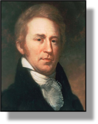
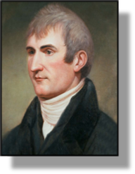 xxxxxIt was a well-planned operation, aimed at locating Indian tribes, selecting sites for trading stations, and gaining information about the wildlife and soil conditions of the region. All members of the expedition, some 40 in number, were given intensive outdoor training in expeditionary skills, such as carpentry, gun repair and night navigation, and were required to specialize in various subjects, including botany, zoology and meteorology. Tuition was even given in Indian sign language in the hope that this would help to keep on friendly terms with the local natives. An experienced army captain, Meriwether Lewis (1774-1809) was selected to lead the party (illustrated left), and he chose another Virginian, Lieutenant William Clark (1770-1838), to share the leadership (illustrated right). This proved a harmonious working partnership, and contributed in large measure to the overall success of the venture.
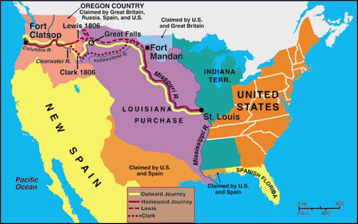
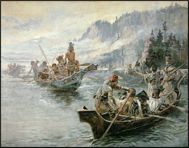 xxxxxBy the time the expedition was ready to start out from St. Charles, Missouri, in May 1804, America had acquired the vast area from the Mississippi to the Rocky Mountains by means of the Louisiana Purchase, agreed in April 1803, and so the whole enterprise had taken on a much greater significance. The party ascended the Missouri in three boats - a hazardous journey at the river’s upper reaches - and in the October built Fort Mandan in modern North Dakota (near present-day Stanton) to spend the winter. From here on Lewis and Clark had the services of a French-Canadian interpreter named Toussaint Charbonneau (1767-1843), and his Indian wife Sacajawea (illustrated), who proved particularly valuable in winning over the friendship of the local Indians - or most of them! Having reached present-day Montana, horses were obtained to ride over the Rocky
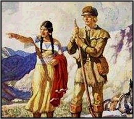 Mountains, and then canoes were constructed to descend by Clearwater River, Snake River and Columbia River to the Pacific Ocean. By then it was December 1805, and the expedition decided to build Fort Clatsop on the southern side of the river - a decision taken by all members of the party - as their winter quarters. They began their return journey the following March, and reached St. Louis towards the end of September 1806, completing an epic journey which, despite the difficult terrain, the severe winter conditions, and the danger from hostile natives and grizzly bears, only cost the life of one man.
xxxxxAs a reward for their successful undertaking, Lewis and Clark - both of whom (but especially the latter) had shown outstanding leadership qualities - each received 1,600 acres of land, and every other member of the expedition was rewarded with 320 acres and double pay. Lewis went on to become the governor of the Louisiana Territory, but died in mysterious circumstances in 1809 whilst traveling to Washington, his death caused either by suicide or murder. Clark was promoted to brigadier general, appointed Superintendent of Indian Affairs, and became governor of the Missouri Territory in 1813.
xxxxxThe maps that were made during the Lewis and Clark expedition, together with the copious and detailed notes made throughout the journey, were to prove of great value in the opening up of the West which was to follow - an area rich in furs and timber. But other explorers and map makers were hard on their heels. A year after the expedition returned to St. Louis, the English geographer and fur trader David Thompson (1770-1857), a former employee of the Hudson Bay Company, crossed the Rocky Mountains and established the first trading post on the Columbia River. He then went on to explore and survey the entire length of this river. He reached its mouth in 1811, only to find that the Americans were building Fort Astoria there as the centre of a trading post. He later settled near Montreal, and completed a useful map of western Canada in 1814. And during this period the Canadian explorer Simon Fraser (1776-1862) set up the first trading post on McLeod Lake, southern Alberta, in 1805, and, three years later, descended the hazardous river later named after him, reaching the Pacific Ocean near present-day Vancouver.
xxxxxIncidentally, in 1818 a convention between Great Britain and America made the 49th parallel (49 N latitude) the boundary between Canada and the United States from the Lake of the Woods (300 miles west of Lake Superior) to the Rocky Mountains. After a lengthy, often heated dispute, the border was eventually extended to the Pacific Ocean by the Treaty of Oregon in 1846 (Va). ……
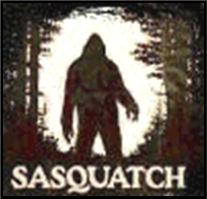 xxxxx…… According to some accounts, in 1811 the English explorer David Thompson was the first to discover a set of footprints alleged to have been made by the Sasquatch, a “wild man” thought by some to inhabit the north-western region of North America. Based on the finding of other footprints and some “sightings”, it was a hairy, manlike creature, standing some 6 to 12 feet tall, and with footprints measuring 24 inches long and 8 inches wide. Akin to the Abominable Snowman or Yeti, none of the evidence so far has been positively proven.
Including:
Matthew Flinders and
William Scoresby & son

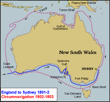 xxxxxIn Australia, as we have seen, the English navigator Matthew Flinders (1774-1814) explored part of the coast of New South Wales with his countryman George Bass in 1795, and together they circumnavigated Tasmania in 1798 - then known as Van Diemen’s Land - , proving once and for all that it was an island. Flinders entered the Royal Navy in 1789. He met Bass while serving aboard the Reliance, and it was then that they explored parts of the Australian coastline together. In 1801, as commander of the Investigator, he again visited Australia. On this occasion he surveyed the length of the south coast (composed for the most part of the Great Australian Bight) and then, departing from Port Jackson (today’s Sydney), he sailed north, charting the east coast, threading his way through the Great Barrier Reef, and reaching the Gulf of Carpentaria in the north. He then continued westward and, keeping the shoreline
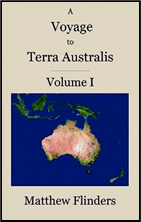 close by, became the first explorer to circumnavigate the continent of Australia, returning to Port Jackson in June 1803. Unfortunately for him, on his return voyage to England his ship began to leak, and he was forced to stop at the Ile de France (today’s Mauritius). Here, with the Napoleonic Wars having just started, he was interned on the island and was not allowed to resume his journey until 1810. On his return, he wrote up his Voyage to Terra Australis - the name he himself gave to the continent - and it was published shortly before his death in 1814. Understandably, his name is perpetuated by a number of geographical features, including a river in Queensland, a mountain range in South Australia, and several islands.
xxxxxButxwhilst, by the turn of the century, the coastline was moderately well known, the interior of this vast new continent was certainly not. The Great Dividing Range, stretching down the east coast, had seen to that. It was not until 1813, in fact, that the Australian explorer Gregory Blaxland (1778-1853) managed to cross the Blue Mountains, a range west of today’s Sydney. The rivers he found supported the idea of an inland sea, and this was thought to be the case by the next adventurer who crossed the mountain barrier, the Englishman John Oxley (1783-1828) in 1818. It was the explorer Charles Sturt who proved that the heart of the continent was, in truth, one vast desert, but, as we shall see, this was to be some years after his exploration of the river system of south-east Australia in 1828 (G4). And many more expeditions were to be needed after his before the entire nature of Terra Australis was revealed.
xxxxxAs we have seen, the English navigator Matthew Flinders (1774-1814) explored the coast of New South Wales with his fellow countryman George Bass in 1795, and three years later they circumnavigated Tasmania. In 1801 Flinders returned to the region and circumnavigated the entire continent, charting much of the coastline as he went. He returned to England in 1810, and his Voyage to Terra Australis - the name he himself gave to the continent - was published in 1814, the year of his death. Many geographical features in Australia are named after him, including a river, a mountain range and a number of islands.
G3c-1802-1820-G3c-1802-1820-G3c-1802-1820-G3c-1802-1820-G3c-1802-1820-G3c
xxxxxIn 1806 the English whaler and amateur scientist William Scoresby (1760-1829) reached as far north as 81 12’N, a record for that time. He introduced a number of aids to ice navigation, and invented the barrel crow’s nest in which to spot fish shoals. His son, William Scoresby the Younger (1789-1857), later explored and mapped part of the east coast of Greenland, and in 1820 he published his Account of the Arctic Regions, a work which became a standard reference book. His scientific studies concerning the variation of sea temperature, and the effect of magnetism on navigation, brought him in contact, amongst others, with the English naturalist Joseph Banks and the English physicist Michael Faraday.
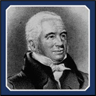 xxxxxThe scientific exploration of the Arctic began with the sailings of William Scoresby (1760-1829) an English whaler and amateur scientist who in 1806 captained the first ship to enter the Polar Sea and reached as far north as 81 12’N, breaking through the ice at Spitsbergen. As noted earlier, before this date there had been no real attempt to penetrate the North Polar Region by way of discovery, though a large number of navigators had skirted the area in an attempt to find a passage from Europe to Asia. Men like Martin Frobisher and John Davis in the 16th century, for example, and Henry Hudson and William Baffin in the 17th, had searched for such a passage from the North Atlantic, whilst the 18th century navigators James Cook and George Vancouver had made their attempts from the Pacific side. Over these three centuries some geographic knowledge of this inhabitable area had been accumulated by whalers - notably English, Dutch and Norwegian - and some maps had been made, but little detailed observation of the territory had been recorded. At the beginning of the 19th century the search for this elusive waterway was resumed.
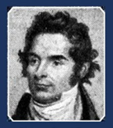
xxxxxScoresby, a farmer’s son, was an outstanding navigator, and his whaling voyage of 1806 aboard the Resolution was a record for that time, reaching just 510 miles short of the North Pole. Based on his many years of experience, he introduced a number of aids to ice navigation, invented the barrel crow’s nest in 1807 - as a more sheltered means of spotting fish shoals - and was the first to suggest the idea of using sledges to reach the North Pole. He was accompanied on his voyage by his son, William Scoresby the Younger (1789-1857) (illustrated).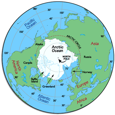 Then aged 16, he continued his father’s research, and in 1820 published his Account of the Arctic Regions with a History and Description of the Northern Whale-Fishery, a work which included findings by earlier navigators and became a standard reference book. Two years later he visited Greenland where he produced a detailed map of 400 miles of the east coast. His experiments included the recording of sea temperatures at different levels, and the effect of a ship’s magnetism upon the working of a compass, and, by this work, he became acquainted, amongst others, with the English botanist Joseph Banks and the English physicist Michael Faraday. His drawings and paintings of the region showed animals and plants not seen before. After this voyage to Greenland, however, he was lost to arctic research. He studied divinity at Cambridge University and became a clergyman.
xxxxxThe work and findings of William Scoresby and his son marked but the start of the exploration of the arctic region. As we shall see (1828 G4), others soon began to penetrate further into the northern ice cap, whilst at the South Pole, land was sighted for the first time and aroused an interest in the Antarctic, the last of the continents.
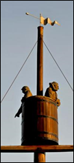
xxxxxIncidentally, bronze statues of Captain Scoresby and his son - appropriately keeping watch in a barrel crow’s nest - are to be seen on the quayside of Whitby Harbour in Yorkshire, the fishing port where both men worked. ……
xxxxx…… In the church of St. Mary, Whitby, where William Scoresby the Elder is buried, is the “Scoresby Chair”. This was carved out of the wreck of the Royal Charter, a ship used by the younger Scoresby during one of his scientific expeditions. He returned to this church as a curate in 1826 to preach at a memorial service for 65 men, drowned when two local whaling ships were lost at sea.